Housing and economic land availability assessment
Sets out method for assessing housing and economic land availability.
This guidance has been updated see previous version
Guidance on 5 year housing land supply and Housing Delivery Test can now be found in the Housing supply and delivery guidance.
What is the purpose of the assessment of land availability?
An assessment of land availability identifies a future supply of land which is suitable, available and achievable for housing and economic development uses over the plan period. The assessment is an important source of evidence to inform plan-making and decision-taking, and the identification of a 5-year supply of housing land. It can also inform as well as make use of sites in brownfield registers
However, the assessment does not in itself determine whether a site should be allocated for development. It is the role of the assessment to provide information on the range of sites which are available to meet the local authority’s (or, where relevant, elected Mayor or combined authority) requirements, but it is for the development plan itself to determine which of those sites are the most suitable to meet those requirements.
Plan-making authorities may carry out land availability assessments for housing and economic development as part of the same exercise, in order that sites may be identified for the use(s) which is most appropriate.
An assessment should:
- identify sites and broad locations with potential for development;
- assess their development potential; and
- assess their suitability for development and the likelihood of development coming forward (the availability and achievability).
This guidance should be read in conjunction with separate guidance on the application of town centre planning policy, which includes the sequential test for locating town centre use as well as guidance on making the most effective use of land.
Paragraph: 001 Reference ID: 3-001-20190722
Revision date: 22 07 2019
Should plan-makers override constraints, such as Green Belt, when carrying out the assessment to meet identified needs?
Plan-making bodies should consider constraints when assessing the suitability, availability and achievability of sites and broad locations. For example, assessments should reflect the policies in footnote 6 of the National Planning Policy Framework, which sets out the areas where the Framework would provide strong reasons for restricting the overall scale, type or distribution of development in the plan area (such as the Green Belt and other protected areas).
Paragraph: 002 Reference ID: 3-002-20190722
Revision date: 22 07 2019
Can neighbourhood planning bodies use the guidance?
Neighbourhood planning bodies may use the method set out in this guidance to assess sites but any assessment needs to be proportionate to the nature of the plan. Neighbourhood planning bodies may also make use of existing site assessments prepared by the local planning authority as a starting point when identifying sites to allocate within a neighbourhood plan.
Paragraph: 003 Reference ID: 3-003-20190722
Revision date: 22 07 2019
Can plan-making authorities use a different method?
This guidance indicates what inputs and processes can lead to a robust assessment of land availability. Plan-making bodies are expected to have regard to the guidance in preparing and updating their assessments. Where they depart from the guidance, it will be important to explain the reasons for doing so when setting out the evidence base that informs the plan. Assessment needs to be thorough but proportionate, building where possible on existing information sources outlined within the guidance.
Paragraph: 004 Reference ID: 3-004-20190722
Revision date: 22 07 2019
Method – flowchart
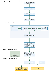
Paragraph: 005 Reference ID: 3-005-20190722
Revision date: 22 07 2019
Method – Stage 1: Identification of sites and broad locations
Determine assessment area and site size
What geographical area should the assessment cover?
The area selected for the assessment should be the plan-making area. This could be the local planning authority area, 2 or more local authority areas, areas covered by a spatial development strategy, or areas covered by the Local Enterprise Partnership.
Paragraph: 006 Reference ID: 3-006-20190722
Revision date: 22 07 2019
Who can plan makers work with?
The assessment needs to be undertaken and regularly reviewed working with other local planning authorities in the relevant housing market area or functional economic market area, in line with the duty to cooperate and need to maintain statements of common ground.
It is also important to involve land owners and promoters; local property agents; developers; local communities; Local Enterprise Partnerships; businesses and their local representative organisations; parish and town councils and neighbourhood forums preparing neighbourhood plans.
Paragraph: 007 Reference ID: 3-007-20190722
Revision date: 22 07 2019
Can the assessment be constrained by the need for development?
The assessment needs to identify all sites and broad locations (regardless of the amount of development needed) in order to provide a complete audit of available land. The process of the assessment will, however, provide the information to enable an identification of sites and locations that are most suitable for the level of development required.
Paragraph: 008 Reference ID: 3-008-20190722
Revision date: 22 07 2019
What sizes of site or broad locations can be considered for assessment?
Plan-makers will need to assess a range of different site sizes from small-scale sites to opportunities for large-scale developments such as village and town extensions and new settlements where appropriate.
It may be appropriate to consider all sites and broad locations capable of delivering 5 or more dwellings, or economic development on sites of 0.25 hectares (or 500 square metres of floor space) and above. Plan-makers may wish to consider alternative site size thresholds. The National Planning Policy Framework expects a minimum proportion of the sites identified as suitable for housing to be no larger than one hectare, unless there are strong reasons why this cannot be achieved.
Paragraph: 009 Reference ID: 3-009-20190722
Revision date: 22 07 2019
How can sites/broad locations be identified?
When carrying out a desktop review, plan-makers need to be proactive in identifying as wide a range of sites and broad locations for development as possible (including those existing sites that could be improved, intensified or changed). Identified sites, which have particular constraints (such as Green Belt), need to be included in the assessment for the sake of comprehensiveness but these constraints need to be set out clearly, including where they severely restrict development. An important part of the desktop review, however, is to identify sites and their constraints, rather than simply to rule out sites outright which are known to have constraints.
It is important that plan-makers do not simply rely on sites that they have been informed about, but actively identify sites through the desktop review process that may assist in meeting the development needs of an area.
Paragraph: 010 Reference ID: 3-010-20190722
Revision date: 22 07 2019
What types of sites and sources of data should be used?
Plan makers should consider all available types of sites and sources of data that may be relevant in the assessment process but the following may be particularly relevant:

Paragraph: 011 Reference ID: 3-011-20190722
Revision date: 22 07 2019
Can plan makers issue a call for sites and broad locations for development?
If the process to identify land is to be transparent and identify as many potential opportunities as possible, it is important to issue a call for sites and broad locations for development. This needs to be aimed at as wide an audience as is practicable so that those not normally involved in property development have the opportunity to contribute. This can include notifying parish councils and neighbourhood forums, landowners, developers, businesses and relevant local interest groups, as well as local publicity. A call for sites will need to set out the information sought from respondents, which could include:
- site location;
- suggested potential type of development (eg economic development uses – retail, leisure, cultural, office, warehousing etc; residential – by different tenures, types and needs of different groups such as older people housing, private rented housing and people wishing to build or commission their own homes);
- the scale of development; and
- constraints to development.
Paragraph: 012 Reference ID: 3-012-20190722
Revision date: 22 07 2019
What can be included in the site and broad location survey?
The comprehensive list of sites and broad locations derived from data sources and the call for sites. Plan-makers can assess potential sites and broad locations prior to a more detailed survey to:
- ratify inconsistent information gathered through the call for sites and desk assessment;
- get an up to date view on development progress (where sites have planning permission);
- obtain a better understanding of what type and scale of development may be appropriate;
- gain a more detailed understanding of deliverability, any barriers and how they could be overcome; and
- identify further sites with potential for development that were not identified through data sources or the call for sites.
Paragraph: 013 Reference ID: 3-013-20190722
Revision date: 22 07 2019
How detailed does the initial survey need to be?
At this stage, there may be some sites which, when taking into account national policy and designations, it will not be appropriate to carry out these more detailed assessments for, where it is clear that they will not be suitable for development. The initial surveys need to be proportionate, with a more detailed assessment being made at Stage 2.
Sites which do not involve major development with any form of permission and all sites with detailed permission should be considered achievable within the next 5 years, unless evidence indicates otherwise.
Paragraph: 014 Reference ID: 3-014-20190722
Revision date: 22 07 2019
What information should be recorded during the survey?
During the site survey the following information can be recorded (or checked if they were previously identified through the data sources and call for sites):
- site size, boundaries, and location;
- current land use and character;
- land uses and character of surrounding area;
- physical constraints (eg access, contamination, steep slopes, flood risk, natural features of significance, location of infrastructure/utilities);
- potential environmental constraints;
- consistency with the development plan’s policies;
- proximity to services and other infrastructure, such as public transport;
- where relevant, development progress (eg ground works completed, number of units started, number of units completed); and
- initial assessment of whether the site is suitable for a particular type of use or as part of a mixed-use development.
Paragraph: 015 Reference ID: 3-015-20190722
Revision date: 22 07 2019
Method – Stage 2: Site/broad location assessment
Estimating the development potential of each site/broad location
How can the development potential be calculated?
The estimation of the development potential of each identified site can be guided by the existing or emerging plan policy including locally determined policies on density. When assessing development potential, plan makers should seek to make the most efficient use of land in line with policies set out in the National Planning Policy Framework.
Development potential is a significant factor that affects the economic viability of a site / broad location and its suitability for a particular use. Therefore, assessing achievability (including viability) and suitability can usefully be carried out in parallel with estimating the development potential.
Paragraph: 016 Reference ID: 3-016-20190722
Revision date: 22 07 2019
What can be considered by plan-makers when assessing whether sites / broad locations are likely to be developed?
Plan-makers will need to assess the suitability, availability and achievability of sites, including whether the site is economically viable. This will provide information on which a judgement can be made as to whether a site can be considered deliverable within the next five years, or developable over a longer period.
Paragraph: 017 Reference ID: 3-017-20190722
Revision date: 22 07 2019
What factors can be considered when assessing the suitability of sites / broad locations for development?
A site or broad location can be considered suitable if it would provide an appropriate location for development when considered against relevant constraints and their potential to be mitigated.
When considering constraints, plan-makers may wish to consider the information collected as part of the initial site survey, as well as other relevant information, such as:
- national policy;
- appropriateness and likely market attractiveness for the type of development proposed;
- contribution to regeneration priority areas;
- potential impacts including the effect upon landscapes including landscape features, nature and heritage conservation.
Plan-makers need to assess the suitability of identified sites or broad locations for different forms of development where appropriate, taking into account the range of needs for housing, economic and other uses.
When assessing sites against the adopted development plan, plan-makers will need to take account of how up to date the plan policies are and consider the relevance of identified constraints on sites / broad locations and whether such constraints may be overcome. When using the emerging plan to assess suitability, plan-makers will need to account for potential policy changes or other factors which could impact the suitability of the site / broad location. For example, an emerging site allocation may enable development to come forward. This will have to be reflected in the assessment of achievability.
Sites in existing development plans or with planning permission can generally be considered suitable for development although it may be necessary to assess whether circumstances have changed which would alter their suitability. This can be informed by a range of factors including the suitability of the land for different uses and by market signals, which will be useful in identifying the most appropriate use.
Paragraph: 018 Reference ID: 3-018-20190722
Revision date: 22 07 2019
What factors can be considered when assessing availability?
A site can be considered available for development, when, on the best information available (confirmed by the call for sites and information from land owners and legal searches where appropriate), there is confidence that there are no legal or ownership impediments to development. For example, land controlled by a developer or landowner who has expressed an intention to develop may be considered available.
The existence of planning permission can be a good indication of the availability of sites. Sites meeting the definition of deliverable should be considered available unless evidence indicates otherwise. Sites without permission can be considered available within the first five years, further guidance to this is contained in the 5 year housing land supply guidance. Consideration can also be given to the delivery record of the developers or landowners putting forward sites, and whether the planning background of a site shows a history of unimplemented permissions.
Paragraph: 019 Reference ID: 3-019-20190722
Revision date: 22 07 2019
What factors should be considered when assessing achievability including whether the development of the site is viable?
A site is considered achievable for development where there is a reasonable prospect that the particular type of development will be developed on the site at a particular point in time. This is essentially a judgement about the economic viability of a site, and the capacity of the developer to complete and let or sell the development over a certain period.
Paragraph: 020 Reference ID: 3-020-20190722
Revision date: 22 07 2019
What happens when constraints are identified that impact on the suitability, availability and achievability?
Where constraints have been identified, the assessment will need to consider what action could be taken to overcome them. Examples of constraints include policies in the National Planning Policy Framework and the adopted or emerging development plan, which may affect the suitability of the site, and unresolved multiple ownerships, ransom strips tenancies or operational requirements of landowners, which may affect the availability of the site.
Paragraph: 021 Reference ID: 3-021-20190722
Revision date: 22 07 2019
How can the timescale and rate of development be assessed and presented?
Information on suitability, availability, achievability and constraints can be used to assess the timescale within which each site is capable of development. This may include indicative lead-in times and build-out rates for the development of different scales of sites. On the largest sites allowance should be made for several developers to be involved. The advice of developers and local agents will be important in assessing lead-in times and build-out rates by year.
Paragraph: 022 Reference ID: 3-022-20190722
Revision date: 22 07 2019
Method – Stage 3: Windfall assessment (where justified)
Determining the housing potential of windfall sites where justified
How should a windfall allowance be determined in relation to housing?
A windfall allowance may be justified in the anticipated supply if a local planning authority has compelling evidence as set out in paragraph 70 of the National Planning Policy Framework.
Local planning authorities have the ability to identify broad locations in years 6-15, which could include a windfall allowance (using the same criteria as set out in paragraph 67 of the National Planning Policy Framework).
Paragraph: 023 Reference ID: 3-023-20190722
Revision date: 22 07 2019
Method – Stage 4: Assessment review
How should the assessment be reviewed?
Once the sites and broad locations have been assessed, the development potential of all sites can be collected to produce an indicative trajectory. This should set out how much housing and the amount of economic development that can be provided, and at what point in the future (i.e. within years 1 to 5, 6 to 10, and 11 and beyond). An overall risk assessment should be made as to whether sites will come forward as anticipated.
Paragraph: 024 Reference ID: 3-024-20190722
Revision date: 22 07 2019
What happens if the assessment indicates that there are insufficient sites / broad locations to meet needs?
When preparing strategic policies, it may be concluded that insufficient sites / broad locations have been identified to meet objectively assessed needs, including the identified local housing need.
In the first instance, strategic policy-making authorities will need to revisit their assessment, for example to carry out a further call for sites, or changing assumptions about the development potential of particular sites to ensure these make the most efficient use of land. This may include applying a range of densities that reflect the accessibility and potential of different areas, especially for sites in town and city centres, and other locations that are well served by public transport.
If insufficient land remains, then it will be necessary to investigate how this shortfall can best be planned for. If there is clear evidence that strategic policies cannot meet the needs of the area, factoring in the constraints, it will be important to establish how needs might be met in adjoining areas through the process of preparing statements of common ground, and in accordance with the duty to cooperate. If following this, needs cannot be met then the plan-making authority will have to demonstrate the reasons why as part of the plan examination.
Paragraph: 025 Reference ID: 3-025-20190722
Revision date: 22 07 2019
Method – Stage 5: Final Evidence Base
Following the assessment, what are the outputs?
The following set of standard outputs are expected to be produced following the assessment:
- a list of all sites or broad locations considered, cross-referenced to their locations on maps;
- an assessment of each site or broad location, including:
- where these have been discounted, evidence justifying reasons given;
- where these are considered suitable, available and achievable, the potential type and quantity of development, including a reasonable estimate of build out rates, setting out how any barriers to delivery could be overcome and when;
- an indicative trajectory of anticipated development based on the evidence available.
The assessment will need to be made publicly available in an accessible form. Following the assessment authorities can use it to demonstrate whether there is a 5 year housing land supply when plan-making and decision-taking.
Paragraph: 026 Reference ID: 3-026-20190722
Revision date: 22 07 2019
Last updated 22 July 2019 + show all updates
-
Revised version of guidance
-
Added new sections 'Housing delivery: 5 year land supply' and 'Housing Delivery Test' and removed section 'Methodology – Stage 5: Final evidence base'
-
First published.